About 200 rivers of various sizes flow through the region. They belong to the basins of the Azov and Caspian seas, the Caspian and Sarpin drainage basins. Most of the territory of the region is drained by the Don with its tributaries: the Khoper, Bear, ilovlya by Cirom, don Queen, Myshkova, a Aksay, Aksay Serverskin with only 165 rivers. The Volga basin occupies a narrow strip along the Volga valley and includes 30 watercourses.
On the vast territory of the Caspian drainage area (22172 km2) there are few rivers, they flow into the lake. Elton (Smaragda, 'hare Lancp). River related to Verkhniy Sal closed the pool, draining from the Eastern slope of the Yergeni hills and flow into the lake Sarpa and Swell.
The total length of rivers flowing through the territory of the Volgograd region, is 7981 km, 9 of them have a length more than 200 km, their total length within the oblast - 1947 km rivers is due to atmospheric precipitation (80-90% of the total) and groundwater.
Volga, don with large tributaries are used as water transport highways. They built large hydroelectric power plants, created reservoirs, making it possible to use water for hydropower generation and irrigation of fields. The Volga and the don are connected by a navigable canal, through which a deep-water route is laid between the Baltic, White, Caspian and Azov seas.
Volga is the largest river of the European part of Russia. It originates in the Valdai hills from the key lying at an altitude of about 225 m above sea level, near the village Volgo-Verkhovye Ostashkovsky district of the Tver region and flows into the Caspian sea at the level of minus 28 m. the Total length of the Volga is 3531 km. In extent it occupies 14-e a place in the area of the basin (1360 km2) - 12-e, and the average consumption of water (more than 8 thousand m3/h) - 16-e the place among rivers in the world.
On the territory of the Volgograd region, the Volga flows to its lower reaches for 318 km. the basin Area within the area of 15.4 thousand square meters. km.
The largest left tributary of the Volga within the region is Eruslan. Right-Bank tributaries are insignificant in terms of its length and basin area, river Danilovka, Shcherbakovka, Dobrinka, Balalaika. Below the Volgograd Volga does not accept the tributaries. In the area of the Volga it is separated from the Akhtuba branch, which flows parallel to the main channel. Between him and the river Akhtuba formed the Volga-Akhtuba floodplain, reaching a width of 25-30 km. Floodplain cut numerous channels, lakes.
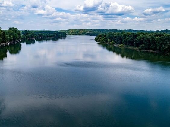
In the Northern part of Volgograd, the river was blocked by a hydroelectric dam, resulting in the formation of the Volgograd reservoir. Volgograd reservoir, which is 546 km long, area-3115 km2, total volume-31.4 km3, useful-8.2 km3. The reservoir is of channel type and is located in a relatively narrow part of the Volga valley. The width of its main part is 4-7 km. in some Places it narrows to 2.5-3.0 km, and in some areas it expands to 10-14 km.
The main channel of the Volga has a width of 1 to 2 km, it is replete with large Islands. (In traktorozavodskoy district of Volgograd are Disputed Islands and Zaitsevsky; downstream formed the island Sarpinsky and Hungry, the last has the greatest width to 10 km). The depth of the Volga below the hydroelectric dam varies from 5 to 15 m, the flow rate of 1.0-1.5 m / sec. In the channel there are numerous shoals, complicating navigation. The banks, composed of sandy rocks, are subject to significant movements, reaching 35-40 meters per year.
The don originates on the southern slope of the Central Russian upland near Epifani, Tula region. The source of the river is considered to be the keys to emerging from limestones in S. Urbanke. The don flows into the Taganrog Bay of the Azov sea, forming a Delta here. The average annual water consumption is 900 m3 / sec. The annual flow is 30 km3. The area of the don basin 422,5 thousand km2, the length of 1870 km of territory of the Volgograd region, the don flows for 537 km, the basin area of 12.1 km2.
The valley of the Lower don was blocked by a hydroelectric dam, resulting in the formation of the Tsimlyansk reservoir. Its water area has an area of 2700 km2, total volume-23.9 km3, including useful-11.5 km3. The average width of the reservoir is about 12 km, the maximum-30 km.
The Tsimlyansk sea has a total length of 260 km and most of it is located within the Volgograd region. With winds up to 20 m / s Tsimlyanskoe reservoir is very stormy. Storm is not uncommon, and the height of the waves reaches 2.5-8.5 m.
Volga-don canal. V. I. Lenin. From the Volga canal passes through the valley of the river Sarpa, then via the Volga-don watershed, using river valley and Scarlet street, out in don (Gulf of Tsimlyansk reservoir) below the city of Kalach. Its longitudinal profile is divided into three sections. The first Volga slope - length of 21 km, with nine gateways, the second watershed - a length of 25 km and Third is for don gentle slope has a length of about 55 km and four of the gateway.
Each of the 13 gateways is a step channel with a height of about 10 m. the Ninth gate is located on the Volga-don watershed at a height of 88 m above the level of the Volga river and is crowned "the Volga stairs." There are no locks on the watershed. Here in the river valley Scarlet created Varvarovsky water reservoir, covering an area of 16 km2. Its bowl holds 124 million m3 of water, which feeds the entire Volga slope of the shipping channel. A 42 km long canal has been dug from this reservoir to the South, and water is supplied to agricultural fields.
The tenth lock is the first step of the "don stairs". Behind it is the Bereslav reservoir, which has an area of about 14 km2 and holds 48 million m3 of water. On the banks of the reservoir are fields and vegetable plantations. The biggest reservoir on the route of the canal Kurovskoe an area of 42 km2, water volume of 155 million m3. Beyond the 13th lock, the canal enters the Tsimlyansk reservoir.
In channel flows the don water, which is sequentially pumped by three pumping stations in Kurovskoe, Bereslavskaya and Varvarovsky reservoir, the sluices of the Volga slope fed by the latter.
The water level in the canal is almost constant all the time. In the winter it is pumped out of the locks, and at this time there is their scheduled maintenance.
The hopper is a left tributary of the don. Originates on the South-Western slope of the Volga upland at an altitude of 200 m in the Penza region. It flows into the don at the village of Ust-Khoperskaya. The distance of 1008 km; on the territory of the Volgograd region it takes place over 325 km, crossing Uryupinsk, Nekhayevskiy, Alexis and Kumylzhensky areas. The total area of the pool hopper 61,1 thousand km2.