The universal model of climate optimization is a new unique method allowing to use regularities of physical processes and peculiarities of climate-forming factors in order to design new landscape and recreational complexes with improved climate.
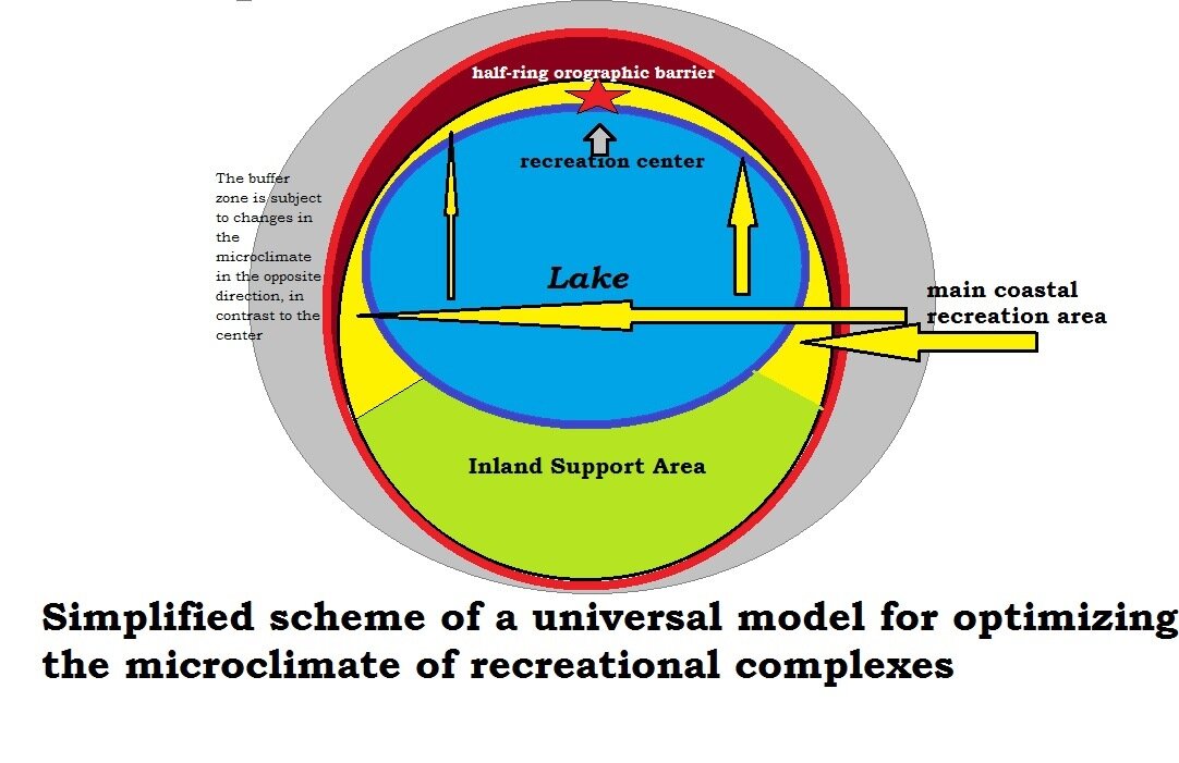
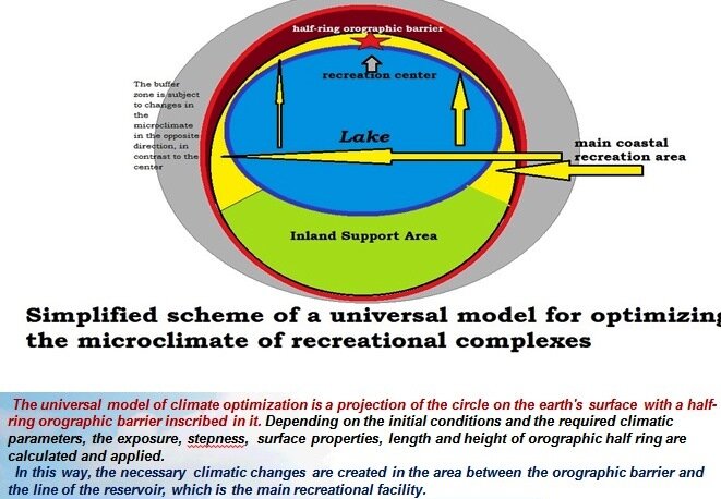
The universal model of climate optimization is a projection of the circle on the earth's surface with a half-circle orographic barrier inscribed in it, changing the exposure, closedness, inner steepness and properties of the slope surface depending on the initial conditions and the required result and creating the necessary climate changes on the land strip between it and the line of the reservoir, which is the main recreational object.
The universal climate optimization model works with varying degrees of efficiency for all regions and scales from micro-relief to planetary dimensions. The multipurpose model can be used either on its own plot of land or on a private island, or, for example, as part of government programmes to improve the microclimate and tourist attractiveness of vast areas in the drylands. The peculiarity of the model is a universal method of artificial orographic semi-circle, whose size, shape and position are calculated depending on the initial climatic conditions as well as the required changes. The theme of the artificial landscape is not entirely new and has a rich historical pattern, but in terms of conscious use of the orographic effect to influence the climate of small areas, this study claims to be unique and requires special attention to the emerging opportunities.
The universal model of microclimate optimization is the future basis for the development of domestic tourism for most countries and a breakthrough in the field of recreation.
The universal model simulates natural origin and natural processes and therefore does not need to maintain order and continues to independently provide the conceived climate, but external energy can temporarily be used to stimulate individual processes.
To improve the microclimate for recreation purposes, changes in different parameters and directions may be required depending on the initial conditions. In most cases, it is necessary to increase the average temperature of air and water in order to prolong the recreational period and increase the thermal attractiveness of the recreation complex in summer. However, in hot countries, it may be necessary to lower the summer temperature, or simply get rid of piercing year-round wind. The advantage of the universal model of microclimate optimization is its multifunctionality: it works in both directions, increases the heating on the one hand and cools the air on the other, increases the humidity in some of its sectors and decreases it in others, muffles the wind in the inner part and sometimes increases it on the outer side. Depending on the orientation of the orographic semicircle, the slope of the surfaces, the landscape and the availability of water bodies, the desired changes in most microclimatic characteristics can be adjusted. Despite the many additional methods of regulation, the effectiveness of changes will depend mainly on the size of the complex and the relative height of the orographic semicircle.
For all landscape-recreational complexes with an optimized climate aimed at increasing temperatures in the surface air layer, the beach line (coastal semi-circle) is assumed to be the main recreational area, while the central water body is the main recreational facility. There are still opportunities for active use of the orographic barrier as an imitation of mountains, the surface of the reservoir and possible islands, as well as the outer side of the orographic semi-circle, which is cooler than the center of recreational area. Infrastructure largely depends on the size and basic idea of the project, which may vary from imitation of wild conditions to implementation of elite service with elements of the water park and technically controlled temperature of water and air.
The geographic range of the model application is primarily related to climate zones and types of initial climate. The author distinguishes 4 categories of territories by the degree of optimization efficiency:
Maximum efficiency: southern temperate zone of the northern hemisphere with continental and sharp continental climate, dry subtropics (including Mediterranean type) and dry tropical climate.
Moderate efficiency: the rest of the temperate zones except for areas with marine and ocean climate type, wet subtropics, monsoon subtropics, some foothills.
Weak efficiency: marine and ocean type of temperate climate, humid tropical climate. Flatlands, low mountains, intermountain spaces.
Very weak effectiveness: equatorial, subequatorial, arctic, subarctic, Antarctic, subantarctic climate zones. Mid-altitude mountains, highlands.
As already mentioned, the main principle of the universal climate optimization model is the orographic barrier with its wind protection effect. It is the absence of wind that can have the maximum effect on the effective temperature (an index characterizing the effect of a complex of weather elements on a person through a single index). Thus, even a two-meter barrier that closes off the wind is able to increase the effective temperature by 10 degrees or more. Thus, for example, at +18°C and 20 m/s wind it is quite possible to freeze and fall ill, and at the same temperature, but the sunny sky and full calm can comfortably sunbathe for many hours.
The second most important effect is an increase in insolation due to the optimal angle of inclination of the inner slopes of the orographic semicircle and the use of dark surfaces (ideal for imitation of volcanic slopes).
The third effect is stabilization of temperature amplitude and accumulation of heat by a water body located in the center of the complex.
All other processes are complementary and are in some way related to the first three.
Orographic half ring exposition
So, to create a barrier effect it is enough to build a straight wall, but the wind has the property to change even during the day, so the barrier in the form of a semicircle will be most effective. The top of the semicircle should point in the direction of the prevailing winds during the recreational period and should probably be the highest point. However, the illuminance of the semicircle is also highly dependent on the position of the sun, so a compromise must be made between these two factors.
The steepness of the orographic barrier slopes
To achieve the maximum effect of heating the slopes, the angle of incidence of sunlight should be as close as possible to 90°. The optimal option for calculating the slope is to choose 2 dates inside the recreational period between the day of the summer solstice and the extreme dates.
Height and length of the orographic barrier
It is possible to recommend the orographic barrier heights at a ratio of 1/10 of the recreational complex diameter as the most acceptable for medium-scale areas. It is assumed that the most effective changes in the microclimate will be felt in recreational complexes with a diameter of more than 3 kilometers and a barrier height of more than 300 meters, respectively. For example, if such a complex is built near Helsinki, on sunny summer days it will give an average temperature in its center comparable to that in central France. The height of the crest will gradually decrease as it moves from the middle of the orographic semi-circle to the edges, but it makes sense not to erect one highest point exactly in the middle of the semi-circle, but to keep one maximum height for about half of the length of the semi-circle. It is also important to consider the aesthetic component and to work out individual ridges, peaks and valleys to create the illusion of naturalness.
Degree of orographic barrier closure
The universal model of microclimate optimization is based on an orographic barrier in the form of a correct semi-circle, but depending on the conditions and requirements it can be reduced to ¼ of the circle perimeter or extended to a full closure. The reduction of the barrier arc can be justified by saving building material if there is no need to increase insolation or if strictly one direction of wind prevails. In severe conditions and with frequently changing wind directions during the recreational period, the orographic barrier may take the form of a closed circle, with the nearest side of the barrier to the equator being much lower than the others and having gentle slopes in order not to prevent sunlight from entering the interior of the complex.
Location and configuration of the central water body
The size of the reservoir directly depends on the possibilities and diameter of the complex. Of course, the filling of half to 2/3 of the inner bowl of the complex will have the greatest effect. If the reservoir is filled with more than 2/3 of the internal space and there are no orographic barriers from one side, the temperature of the reservoir will be affected by external weather factors, so it is better to leave the open side for auxiliary areas, including artificial heaters. If it is impossible to fill a large internal space with water, first of all the territory at the foot of the hills is filled with water in the form of a narrow lake, river or a series of basins so that between the water and the foot of the slopes there is a strip of land no wider than the height of the nearest barrier crest (better less).
When creating a large body of water, it is worth paying attention to the depths. Obviously, the main part of the slopes adjacent to the recreational foot should be shallow and warm quickly, it is also possible to create artificial islands and shoals to give attractiveness to the coast, bays and bays. The main deep-water part of the reservoir can be located exactly in the centre or closer to the outer edge. It also makes sense to make the western edge of the reservoir deeper (for the northern hemisphere), so that in the morning on the western beaches warmed by the sun, the water is warmer than in the shallow waters cooled overnight. Given the size of the reservoir, an additional plus would be the presence of many shallow coves protected from the wind by steep rocks on different sides.
Despite the general principles of the universal model operation for all sizes, the degree of detail of the internal terrain will vary greatly. It is possible to conditionally divide complexes with optimized microclimate into 4 categories:
- Small (mainly for individual use) up to 100 metres in diameter and/or with an orographic barrier height of up to 10 metres.
- Medium size, with a diameter of 100 meters to 1 kilometer and/or orographic barrier height of 10 to 100 meters.
- Large complexes, with a diameter from 1 to 10 kilometers and/or orographic half ring height from 100 meters to 1 kilometer.
-Mega complexes over 10 kilometres in diameter and/or barrier height over one kilometre.
Among the conditions for the selection of territory for the organization of a new landscape and recreational complex with an optimized microclimate should be noted physical and geographical, socio-economic and environmental. By physical-geographical conditions is meant a set of initial natural parameters that allow to judge the effectiveness of the upcoming changes.
The efficiency of microclimate optimization the higher the pronounced continentality of the initial climate and the stronger the seasonality. It is almost impossible to influence the microclimate in humid equatorial climate and in cold areas beyond the polar circle. In a constantly cold or constantly hot climate, the cost of organizing complexes according to the methodology of the universal model of microclimate optimization will not justify those minor changes that may be achieved. It is also difficult to influence the microclimate in a humid ocean climate with weak seasonality with constant fogs and overcast skies, or it will be necessary to build unnecessarily huge orographic barriers.
The environmental conditions for selecting an area are categorical avoidance not only of protected areas, but also of any potentially vulnerable ecosystems. Such recreational facilities, on the contrary, are designed to rehabilitate ecosystems lost as a result of anthropogenic impact and create new green oases in deserted and unforested areas.
Sequence of calculations at designing of recreational complexes on universal model of climate optimization:
1. Analysis of baseline conditions and capabilities
2. Selection of the period of recreation for which the climate will be optimized (micro, local, meso).
3. Determining the exposition of an orographic half ring and, accordingly, the position of its geometric center.
4. Calculation of the optimal duration of the maximum barrier height (default of 25% of a circle or 90°).
5. Determining the degree of closure of an orographic barrier. When the barrier is completely or almost closed, it is necessary to create a form of descending valley for the removal of local cold air, but closed to external.
6. It is necessary to calculate the optimal steepness of slopes for the middle of the orographic barrier and the average position for the points opposite the sun during the recreational period, at the moments of reaching its angle of 8° in the morning and evening, for which the steepness is maximum and is 82-90 degrees. Points with the same isohypses for the upper part of the circle and lateral parts are evenly connected to obtain a concave circular relief shape around the reservoir. The need for completely steep slopes at the base is should be calculated by compromising between windproofing function and maximum insolation, taking into account the scale of the complex and the exposure of a particular part of the slope.
7. The size and position of the reservoir is set and the relief of the bottom is projected.
8. The next stage is the formation of hill-like tops and associated depressions in the form of valleys and canyons, maximally directed perpendicular to the prevailing wind directions and serving as storm drainage and activators of mixing layers of the main water body when flowing into it. At barrier heights of up to 1000 meters, the formation of the spurs and tops at the maximum height is not recommended to avoid the formation of the bora effect (cold and gusty local winds). Secondary landforms are added to beautify the coast and the outer sides of the barrier.
9. Design of spatial and species distribution of vegetation (from plants typical for warmer regions, placed in the warmest place of the recreational zone to the most cold-resistant and humidity-loving on the outer slopes and foothills of the barrier).
10. Design of facilities and infrastructure lines.
11. If necessary, add additional objects of weather engineering and mechanisms of influence on the temperatures of the complex to the project.
12. A quantitative and qualitative forecast of changes is provided.
The above design steps are given taking into account the construction of recreational complex designed to increase the temperature, if necessary to lower the temperature, the recommendations will be different (usually the opposite).
The advantages of using a universal climate optimization model are obvious for almost any country with arid or semi-humid areas. New recreational complexes built on the universal model can give an additional impetus to the development of domestic and inbound tourism and diversify the recreational activity of the area.
The project of creating a universal model of microclimate optimization for recreation in this work is only a breakthrough creative idea, the basis of a new direction in science, creating a vast field of activity in the study of a new vector - climate tourism. Climatic (microclimatic) environmental trails, meteorological attractions, and conscious microclimatic walks are all things that this methodology can enrich modern recreational geography. It is important to understand that the full formation of a universal methodology requires the work of many specialists - ecologists, climatologists, economists, designers, programmers, cartographers and many others. This work requires improvement not possible for one person and even one group of researchers. The author hopes that the international scientific community will accept with dignity and enthusiasm the opportunities offered by the development of a universal model of climate optimization.
In today's world, it is impossible to perform all the detailed calculations to create projects on a universal model without the use of computer programs. Creation of computer program allowing to automate the process of searching of territories, necessary qualitative and quantitative changes, calculating the effect of optimization depending on the scale and methods should become the primary task of further promotion of this scientific work. However, in spite of accuracy and speed of calculations by means of the computer, such work always leaves a place for a method of expert approach and creativity and allows to receive aesthetic satisfaction from process of creation of beauty. Especially if this creation takes place on a global scale and can become a cultural heritage and a gift for future generations.
You can support the development of the channel and related projects with any amount at the link: https://sobe.ru/na/beach_analytics
References
1. Allen S., Mc Quade M. Landform Building: architecture’s new terrain. Princetown University School. Lars Müller ed. 2011. 480 p.
2. Alicov B.P., Poltarouse B.V. Climatology. Publication two. Moscow. Publishing House of Moscow University. 1974
3. Berland M.E. Prediction and regulation of the thermal regime of the surface atmosphere layer. GIMIZ. Leningrad. 1956.
4. Bolonkin, A.A. and R.B. Cathcart, Inflatable ‘Evergreen’ Dome Settlements for Earth’s Polar Regions. Clean. Techn. Environ. Policy. DOI 10.1007/s10098.006-0073.4
5. Claire Portal. Artificial mountains: a new articulated form of nature? Journal of Alpine Research. Revue de géographie alpine *Online+, 105-2. 2017, online 20 June 2017, accessed 29 May 2020. Available at: http://journals.openedition.org/rga/3672; DOI https://doi.org/10.4000/rga.3672,
6. Debarbieux B. Les figures de la montagne dans le projet urbanistique (1870-2010) in Les carnets du paysage. V. 22. 2012. pp. 173-203.
7. Dennis Fernandopullé, Climatic Characteristics of the Canary Islands. Monographiae Biologicae book series (MOBI, volume 30), pp 185-206
8. Kearney, M. R., Isaac, A. P., & Porter, W. P. (2014). Microclim: Global estimates of hourly microclimate based on long‐term monthly climate averages. Scientific Data 1. 140006.
9. Kearney, M. R. (2018b). MicroclimOz – A microclimate data set for Australia, with example applications. Austral Ecology, 44(3), pp. 534–544.
10. Levy, O., Buckley, L. B., Keitt, T. H., & Angilletta, M. J. (2016). A dynamically downscaled projection of past and future microclimates. Ecology 97(7). 1888–1888.
11. Lucien Y. Bronicki, Gad Assaf. Method of and means for weather modification. Patent. Application US06/174,931 events 1980-08-04 Application filed by Geophysical Engineering Co.
12. Maclean, I. M. D., Mosedale, J. R., & Bennie, J. J. (2019). Microclima: An R package for modelling meso‐ and microclimate. Methods in Ecology and Evolution, 10(2), pp. 280–290.
13. Markus Reindel. Mountains in the desert: the monumental architecture of the northern coast of Peru as a reflection of social changes in pre-Hispanic civilizations. Schweizerische-Amerikanisten Gesellschaft Bulletin 63. 1999. pp. 137-148
14. Marzol Jaén, María Victoria, Máyer Suárez, Pablo. Some reflections about the climate of the Canary Islands. Nimbus: Journal of climatology, meteorology and landscape (29). 2012, pp. 399-416
15. Netra R. Regmi, Eric V. McDonald, Craig Rasmussen. Hillslope response under variable microclimate. Earth Surface Processes and Landforms. 10.1002/esp.4686. 44, 13, (2615-2627). (2019).
16. Sapozhnikova S.A. Microclimate and local climate. Hydrometeorological edition. Leningrad. 1950.
17. Wei Yang, Yaolin Lin , and Chun-Qing Li (2018). Effects of Landscape Design on Urban Microclimate and Thermal Comfort in Tropical Climate. Advances in Meteorology. Volume 2018.
You can support the development of the channel and related projects with any amount at the link: https://sobe.ru/na/beach_analytics