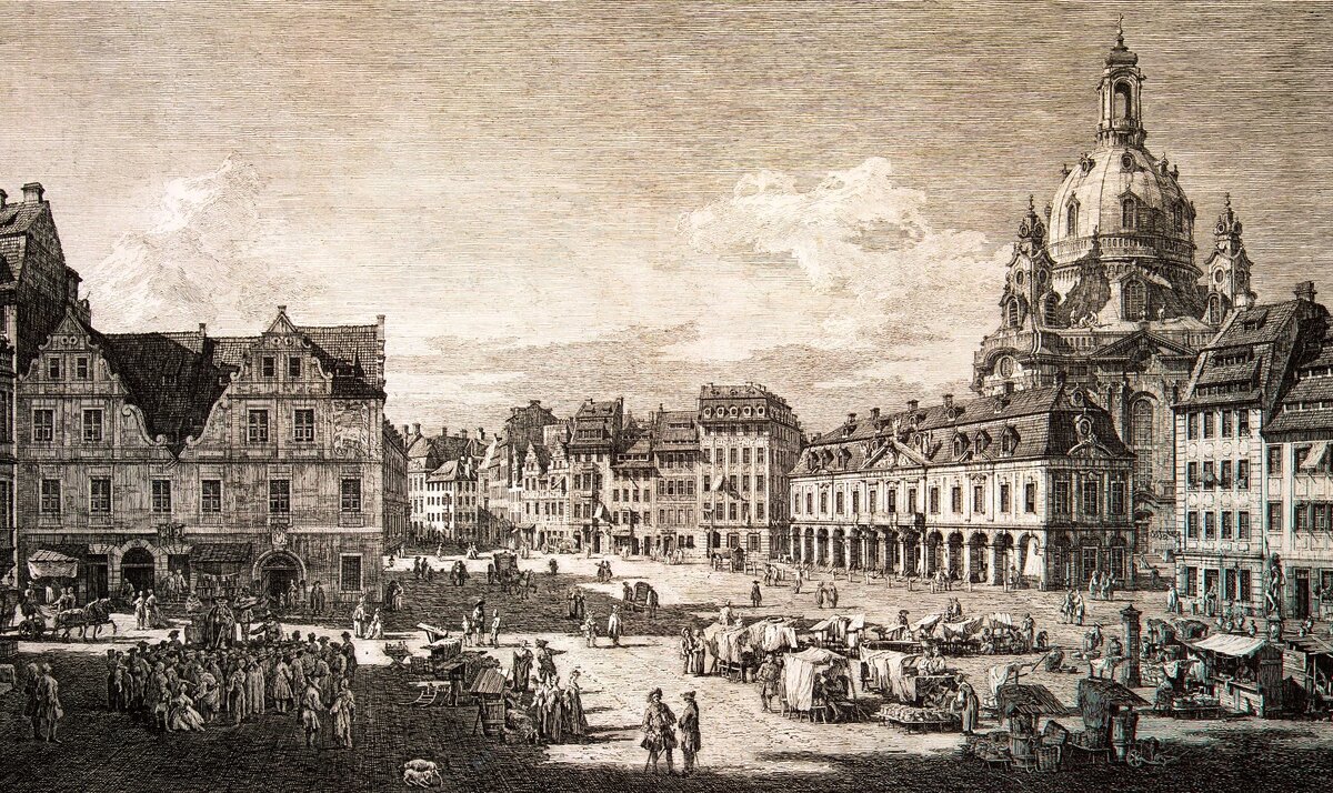
The urban centers of medieval cities had common features, typical of all European cities, which, however, did not exclude a huge variety of architectural and spatial solutions. In the center of the city there was a square, the architectural design of which was made up of closed rows of houses with forceps roofs and contrasting monumental volumes of city churches and town hall. This gave the square a closed character, as well as a variety of compartments. The dominating position in the square and in the city as a whole has always been occupied by the city cathedral.
Despite the simplicity of the architectural and planning structure of medieval European cities, they did not make a chaotic impression. On the contrary, there was a clear structure in the city, as well as the interconnection of architectural verticals with the urban space of streets and squares. All the city gates were crowned with towers, which marked the beginning of the main city communications. The ostracized spires of Gothic churches and the town hall tower pointed to the location of the main squares and the streets connecting them and made it easy to navigate the city. The architecture of the town squares was represented by closed rows of houses with roofs and contrasting monumental volumes of city churches and the town hall.
In the Middle Ages, many new cities were erected according to a premeditated, clear planning scheme. It was more like an architectural fantasy on a certain topic.
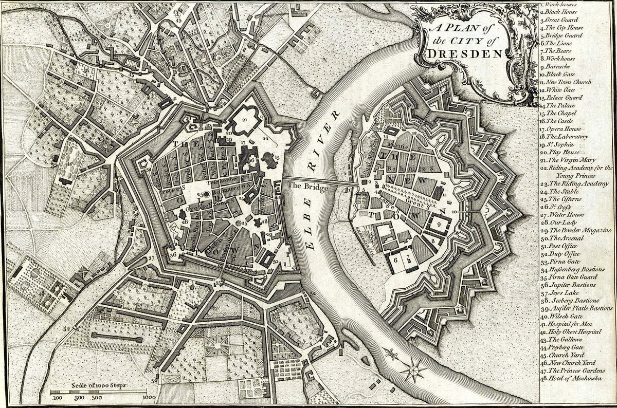
The medieval city of Dresden is an example of such urban planning ideas. The layout of the city of Dresden had a regular layout of streets, which fit into the rounded in terms of fortress walls. This layout was clearly planned in advance. The two main streets of the city crossed at right angles, thus dividing the city into four parts. The design of the crossroads of the main streets symbolized Christianity. This planning scheme was characteristic of most East German cities and was often justified from a functional point of view, as many cities appeared at the crossroads of trade routes. However, the symbolism in urban planning, although it took place, was not its defining feature. It was based on the main needs of urban residents.
The city of Dresden is a unique example of the preservation and development of the historical environment. After Germany united and the new political conditions of the 1990s emerged, the city needed a new development strategy. This was necessary not only to preserve its uniqueness, but also not to survive the "second destruction", which is not related to the war, but to the rapid modernization of the city, because it did not give enough attention and support to the historical heritage. The historical centre was seen as a stimulus for the development of the entire city.
In 1994, at a meeting of the City Planning Department of Dresden, the General Strategy for Planning the Development of the Historic Center was adopted for the first time, and already in 2008 it was revised and refined. The strategy is understood as a spatially oriented concept that constitutes the principles of environmental quality formation. It ensures the preservation of the unique character of Dresden's urban and natural landscape among European cities, presents the city development plan through the integration of new and historical zones. The strategy was developed as a result of the work of an interdisciplinary team of specialists who have found a compromise between desirable and real opportunities and who have set the boundaries for citizens, administration and politicians.
One of the following key points is the Concept of Integrated Development of the City of Dresden 2009. It represents a town-planning analysis of the whole city, divides it into functional zones and assigns each of them a corresponding status after assessment of potential and problem aspects.
The Monument Conservation Department of Dresden has taken into account the preservation and transformation of streets and squares of historical and urban importance, the restoration of the historic image of the city, the reduction of traffic, and the implementation of timely measures to prevent the destruction and collapse of buildings.
During the period of possible destruction of the historical urban areas of Dresden in 1989, it was decided to designate the areas of regeneration in order to prevent careless attitude to the town-planning structure, which has a valuable historical, cultural and town-planning value. The total area of regeneration areas was 294 hectares, they were characterized by unsatisfactory condition of architectural objects and urban environment. To restore the districts, buildings were restored, the living environment was recreated, services and high-quality public spaces were created, for example, playgrounds were created in the structure of streets and squares. As a result, the complex problems of the perestroika period have already been resolved.
In the 17th century, Dresden was a city of two parts on both sides of the river, connected by a bridge. Then the radial layout was initiated and a defensive western wall was built, which was placed with a half ring around the city. The formed plan of the city in the XIX century was preserved in this form for two centuries.
During this time, some changes were made to the landscape and planning structure of the city. Namely: a monumental arch bridge was built, the palace complex was expanded, the eastern half of the old market was built, the embankment was landscaped, a walking alley on two levels with a front staircase and viewpoints was arranged, boulevards were arranged on the place of the city walls, a park with canals and reservoirs was created.
In the second half of the 19th century, a railway was built through Dresden, the line of which stretched along the southern border of the park.
Already in the 20th century, the layout of the city took on a linear character, spreading along the railway and the Elbe, mainly along the left bank.
Currently, some adjustments have been made to the layout of the city, for example, instead of two blocks south of the old market area, a green strip leading to the park has been created. The main street, which runs from the castle to the station, functions as a pedestrian street and is closed to vehicles. Around the round square on the other side of the Elbe, new buildings, green spaces and pedestrian streets have been formed.
The city now has a significant transportation hub, where major highways and 7 railway lines meet, as well as a port on the Elbe River and an international airport.
The urban environment of the city has preserved an integral urban space despite the diversity of shapes, artistic and architectural elements of individual streets.